Article category: Science & Technology, Company News
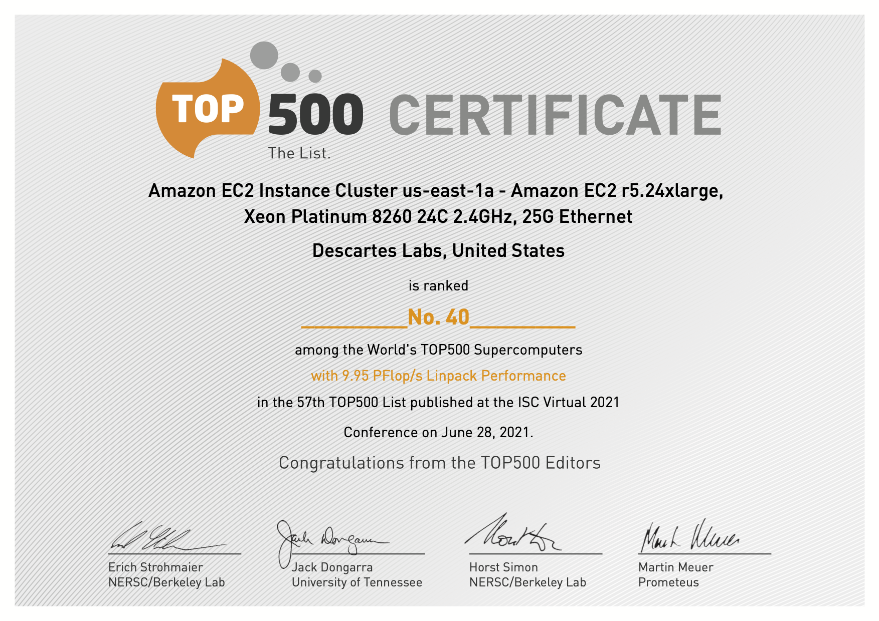
Descartes Labs Achieves #40 in TOP500 with Cloud-based...
Descartes Labs Achieves #41in TOP500 with Cloud-based Supercomputing Demonstration Powered by AWS,...
About 15 months ago, Descartes Labs entered beta to gather feedback from customers on our progress toward developing an advanced platform for global-scale predictive analytics. Getting at that scale required building a cloud-based data refinery to ingest and process enormous and disparate datasets, clean them up, and prepare them for analysis. Finding answers in predictive models also required data—a lot of data. To that end, we are announcing our partnership with Airbus, providing high-resolution global imagery to feed these models.
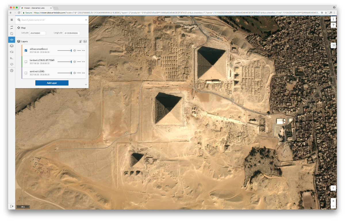
When we entered beta, we offered the entire library of satellite data from the NASA Landsat and ESA Sentinel missions. Now, the entire Airbus OneAtlas catalog is available, making the Descartes Labs Platform the first place that users can do their own machine learning modeling directly on the OneAtlas basemap. This data is very high-resolution, operating at 1.5m per pixel over the entire world, and at 50cm per pixel over the top 2,600 cities. Compare this with the 30m per pixel resolution provided by Landsat data, and you can imagine a world of hidden answers becoming visible.
Along with more imagery, we added our first non-satellite data, weather. We have interpolated NOAA’s Global Surface Summary of the Day (GSOD) dataset, turning those weather data points into usable rasters on our platform. Weather impacts every element of the commodities supply chain. One example, shipping and transportation of goods—from raw materials to final consumer products—the ability to get things where they need to go is heavily impacted by weather conditions.
During the course of our beta, we developed tools to make managing this deluge of data possible. One output of that work is Viewer. Viewer allows you to easily navigate any imagery in our archive—including imagery you upload—on a web-based map. You can select different bands to view, move through a time series of imagery, and label reference data.
You can load different catalogs of datasets into discrete layers, adjust transparency, view or hide any of the layers you are working with, and easily manipulate vector data. We are also rolling out the ability to upload data directly into our archive, and to save products created with the data. Your data is protected in its own sandbox, and is integrated into our catalog to make fusing datasets smooth.
Once you have all the data, you need horsepower. Using our customized infrastructure running on Google Cloud Platform, we can quickly deploy thousands of CPUs and process quadrillions of pixels to handle any model’s requirements. The entire goal for the technology is to accelerate science by automatically removing obstacles, like processing images, correcting for clouds, etc., and providing resources to run massive, near real-time analysis at scale. We have processed over 11 petabytes of compressed data into our platform, and continue to process 9 terabytes of new data daily.
So what does this all mean? It means that Descartes Labs’ customers can experiment and learn faster to make better decisions. They can determine a problem, gather the necessary data, envision and test the right learning models, and process and analyze the answers.
We now have the ability to understand and learn from commodity supply chains as living, organic systems. Businesses can see the relationships and impacts of changes across the globe, looking for signals and evidence of real-world trends. We can unlock answers to the world’s most intractable problems connected directly to immediate business and industry challenges. Things that affect us all, like deforestation and sustainable agriculture, can be confronted by delivering a clear view, a way to generate solutions and get ahead of problems with predictive analytics.
During our beta, we learned a lot and worked with many interesting people. Researchers from Los Alamos National Labs used our platform to track the spread of infectious Dengue in Brazil with the goal of forecasting disease outbreaks by understanding how they spread. We also worked with DARPA to forecast food security issues in the Middle East and North Africa, and Cargill, one of our earliest and most supportive customers and an investor in our last funding round, to explore advantages across multiple business areas.
Ultimately, we found that commercial and government customers shared a common goal for using this technology: to gain advantages in their decision making and discover answers faster. As we emerge from beta, we are just getting started. Our roadmap in the coming months will continue to be driven by solving meaningful problems, at the scale and pace of a fast-moving world. We invite you to contact us at sales@descarteslabs.com to tell us the tough problems you are trying to solve.
Visit us at descarteslabs.com.