Article category: Climate Solutions
Putting our Wildfire Detector to Work in New Mexico
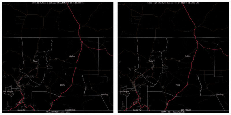
In 2018, approximately 360,500 acres burned across our headquarters’ state of New Mexico. After a...
Descartes Labs has built an operational wildfire detector using satellite imagery which enabled the Los Angeles Times to release the first public report of the Kincade Fire.
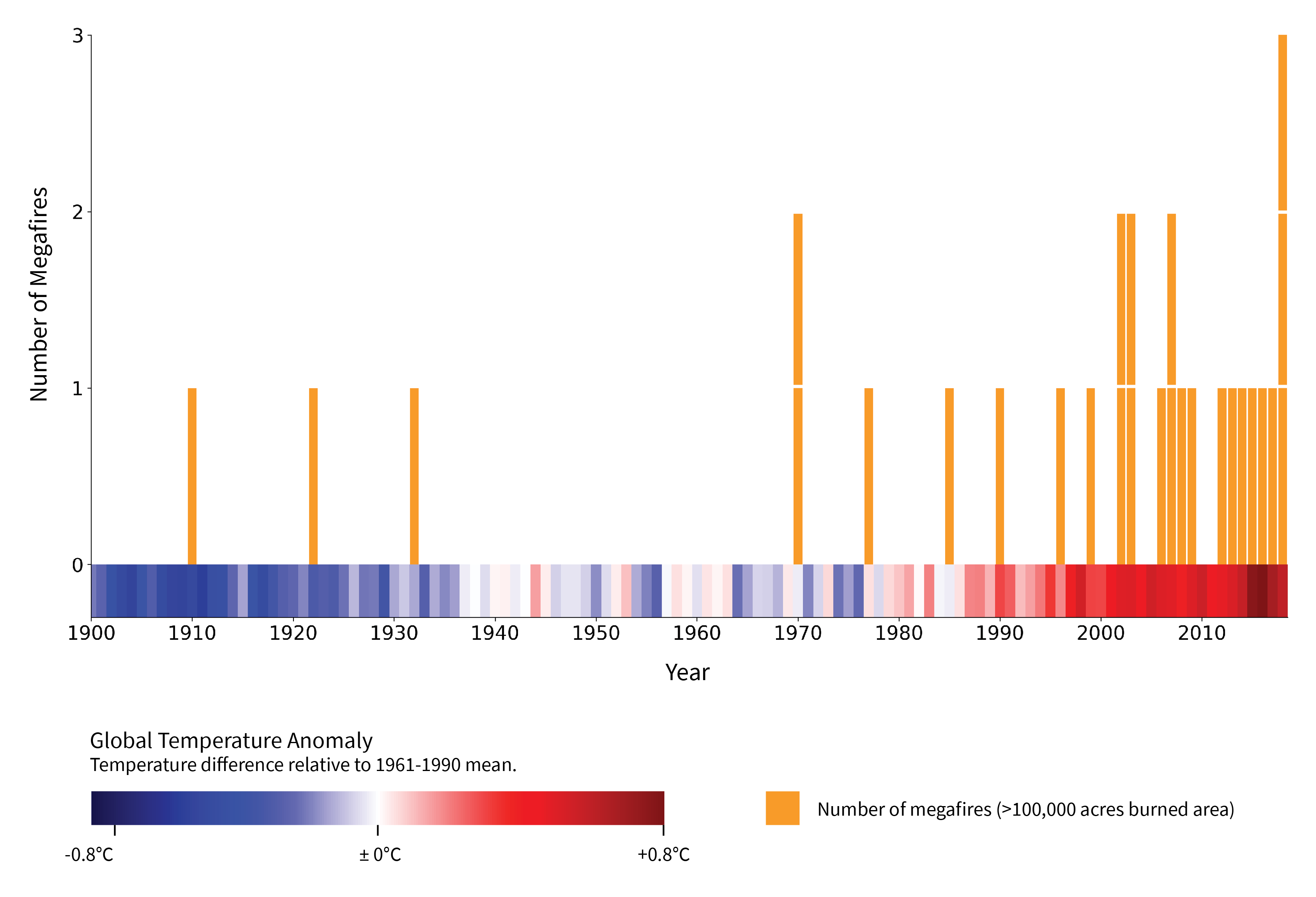
Megafires, defined by the US Forest Service as wildfires that burn over 100,000 acres, are occurring with increased frequency as a result of climate change and the present-day consequences of historical forest management policies. California, whose residents used to experience a megafire once every few decades, has witnessed at least one such blaze on an annual basis for the past seven years. A recent example includes 2018’s Camp Fire, which ignited as a result of a PG&E transmission line failure and spread rapidly through Paradise, resulting in 85 lives lost. That megafire followed 2017’s Thomas Fire, which burned through Ventura County overnight, leaving 23 dead after the ensuing landslides. Although the Kincade Fire currently burning in Sonoma County now appears unlikely to surpass the megafire threshold, history suggests that it’s likely a harbinger of what’s to come.

Typically, it’s a wildfire’s speed that causes it to grow into a megafire, prompting fire managers to keep a close eye on what they call a fire’s “rate of spread.” Wildfires with a dangerous rate of spread often leave authorities with difficult decisions: Should we prioritize fire suppression, or should we just get people out of the way? The earlier a potential megafire is identified, the more options will be on the table as fire managers choose the most prudent course of action.
Historically, it’s been civilians who report wildfires to the authorities and public at large. Often, wildfires are spotted from where people live, from where they’re traveling on the road, or, at times, by commercial pilots flying overhead. Fire agencies are also actively looking for wildfires: a network of manned fire lookout towers dot the hills and mountaintops of the American west. However, many of these towers, which were built in the early 1900s, have fallen into disrepair in the past few decades. In lieu of rebuilding them, fire agencies now lean more heavily on dedicated reconnaissance flights — which are expensive and tend to be carried out sparingly during periods of high risk.
While these modes of wildfire detection have together proven incredibly effective over the years, they do contain a few large gaps in coverage, both spatially and temporally. Although California is the most populous state in the U.S., it is also the third largest in area. Since residents tend to be clustered in city centers, this leaves few or no eyes watching for fires in more remote areas. The level of monitoring also changes drastically as day turns to night: people go to sleep, there are fewer drivers on the road, air traffic thins out considerably overhead. In addition, most wildfires are spotted from the smoke they produce — as opposed to their flames — and smoke is more difficult to spot under the cover of the night. These were the conditions during the ignition of the Kincade Fire, which was first reported at 9:27 PM, more than three hours after sunset.
Descartes Labs is headquartered in northern New Mexico, so the threat of wildfires is particularly present in our minds. In fact, a number of Descartes Labs’ founders were evacuated during the Cerro Grande and Los Conchas megafires, which struck Los Alamos in 2000 and 2011, respectively. After a winter without snow led to a disastrous wildfire season in 2018, we decided to build an automated, early-warning wildfire detector, leveraging what we know best: satellite imagery and AI.
There are many plusses to satellites, including their ability to see the entire country at once, both day and night. However, being in space, they present a coarser view of reality than eyes on the ground. Therefore, with our wildfire detector, our goal was to augment, rather than replace, the existing network of human-oriented detection modes.
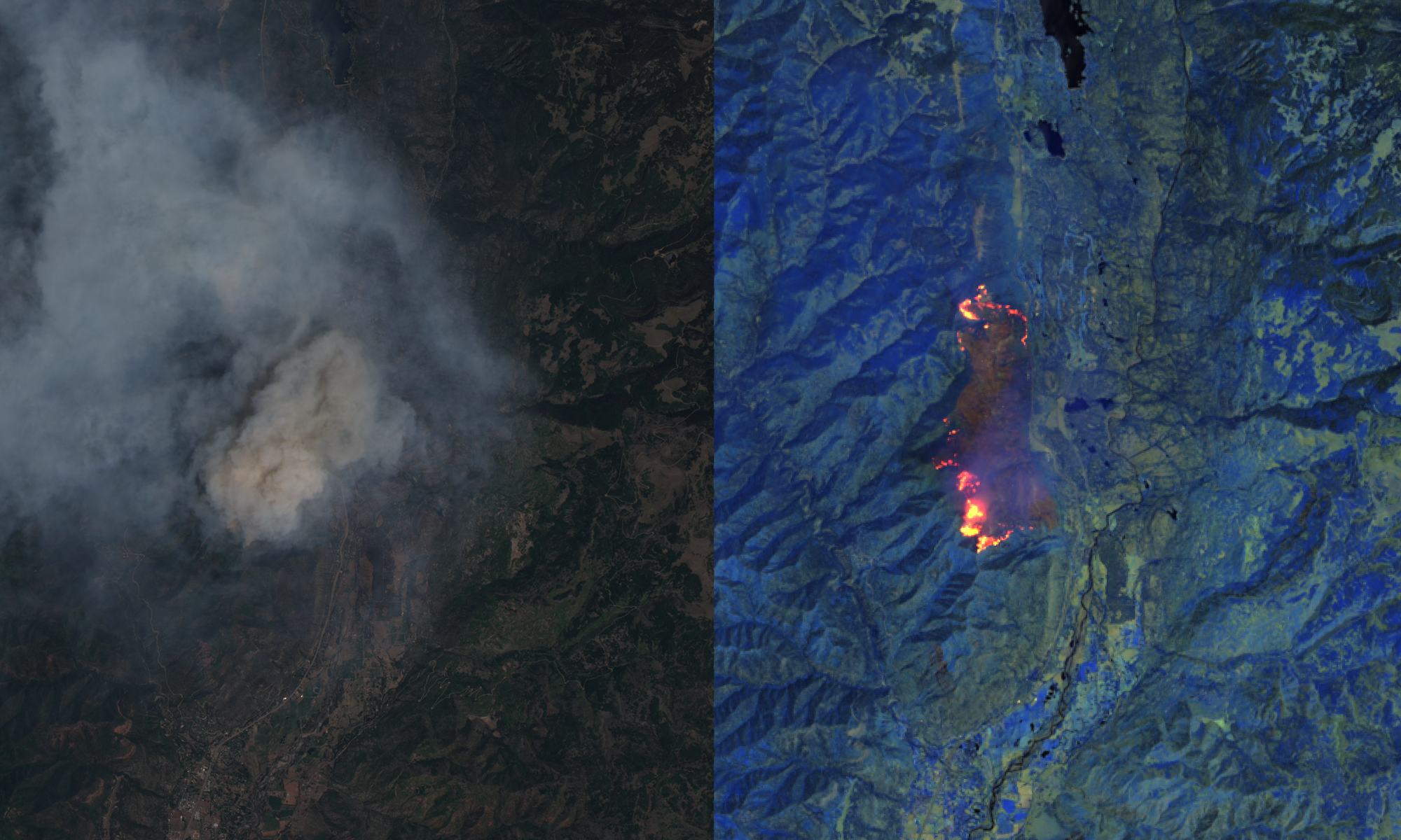
GOES-16 and GOES-17, a pair of recently operational geostationary weather satellites from NOAA, form the basis of our wildfire detector. These satellites provide overlapping views of the western hemisphere and are ideal for spotting wildfires early for a number of reasons. First, they view the earth in near real-time, capturing images of the United States every five minutes. Second, they capture images in the thermal infrared spectrum, enabling us to measure the temperature of the earth at the time an image is taken. Since wildfires are hot, they appear as bright, high-contrast hotspots in thermal infrared imagery, making detection easier. (The caveat being, the size of GOES pixels are 2×2 km — pretty coarse, even for a satellite. This doesn’t mean fires need to be 2×2 km in size to be detectable, but they do need to be sufficiently concentrated and hot enough to raise the temperature of a given pixel above a detectable threshold.) Altogether, these features have enabled us to build a wildfire detector that is essentially real-time, always on, and that sees the entire United States.
While the pair of GOES satellites provides us with a dependable source of imagery, we still needed to figure out how to identify and detect fires within the images themselves. We started simple: wildfires are hot. They are also hotter than anything around them, and hotter than at any point in the recent past. Crucially, we also know that wildfires start small and are pretty rare for a given location, so our strategy is to model what the earth looks like in the absence of a wildfire, and compare it to the situation that the pair GOES satellites presents to us. Put another way our wildfire detector is essentially looking for thermal anomalies.
And it works. The Descartes Labs wildfire detector has been operational and keeping its watchful eye on the United States since July 1st, 2019. In that time, it’s captured the ignition of a great many fires, the Kincade Fire included.
The Kincade Fire is an interesting one because it began under remarkably similar conditions as the Tubbs fire two years earlier: both igniting at around 9:30 PM on an October evening in Sonoma County as a result of an electrical failure. Their burn scars even overlap. But this is where the similarities end. Eleven minutes after the Kincade Fire was reported to Cal Fire, but before firefighters knew precisely where the fire was burning, our wildfire detector broadcast an alert to the LA Times, with latitude and longitude coordinates, where it was automatically reported to the public at large. It would be another 30 minutes before aircraft were circling the fire, and hours before Cal Fire would announce the wildfire.
No official notice of #KincadeFire yet by @CALFIRE_PIO, but our @latimes live wildfires map has already spotted the blaze from space via exclusive @DescartesLabs satellite scanning algorithm.https://t.co/a2XSpxMbTy pic.twitter.com/nQDx380WhQ
— Ben Welsh (@palewire) October 24, 2019
In many ways, this scenario heralds the beginning of a digital transformation in how we identify wildfires, suppress them, and evacuate people at risk. And it is a transformation that we are not carrying out alone: a few hours after we detected the Kincade Fire, a consortium of universities tweeted that their ALERTWildfire system, a network of cameras that could well replace manned fire lookout towers in the near future, had precisely located the blaze.
As sensor data and AI technologies continue to advance, the challenge of early wildfire detection shifts from a wholly technical pursuit to one that includes better communication and collaboration. We are eager to work with businesses and agencies that would benefit from our early wildfire detection technology. Please reach out at hello@descarteslabs.com.